Traditional vertical coordinate choices [z-level, terrain-following (sigma), isopycnic] are not by themselves optimal everywhere in the ocean, as pointed out by recent model comparison exercises performed in Europe (DYnamics of North Atlantic MOdels - DYNAMO) and in the U.S. (Data Assimilation and Model Evaluation Experiment - DAMEE). Ideally, an ocean general circulation model (OGCM) should (a) retain its water mass characteristics for centuries (a characteristic of isopycnic coordinates), (b) have high vertical resolution in the surface mixed layer (a characteristic of z-level coordinates) for proper representation of thermodynamical and biochemical processes, (c) maintain sufficient vertical resolution in unstratified or weakly-stratified regions of the ocean, and (d) have high vertical resolution in coastal regions (a characteristic of terrain-following coordinates).
The hybrid coordinate is one that is isopycnal in the open, stratified ocean, but smoothly reverts to a terrain-following coordinate in shallow coastal regions, and to z-level coordinates in the mixed layer and/or unstratified seas. The hybrid coordinate extends the geographic range of applicability of traditional isopycnic coordinate circulation models (the basis of the present hybrid code), such as the Miami Isopycnic Coordinate Ocean Model (MICOM) and the Navy Layered Ocean Model (NLOM), toward shallow coastal seas and unstratified parts of the world ocean. The theoretical foundation for implementing such a coordinate was set forth in Bleck and Boudra (1981) and Bleck and Benjamin (1993). In HYCOM, each coordinate surface is assigned a reference isopycnal. The model continually checks whether or not grid points lie on their reference isopycnals and, if not, tries to move them vertically toward the latter. However, the grid points are not allowed to migrate when this would lead to excessive crowding of coordinate surfaces. Thus, in shallow water, vertical grid points are geometrically constrained to remain at a fixed depth while being allowed to join and follow their reference isopycnals over the adjacent deep ocean.
In the mixed layer, grid points are placed vertically so that a smooth transition of each layer interface from an isopycnic to a constant-depth surface occurs where the interface outcrops into the mixed layer. HYCOM therefore behaves like a conventional sigma model in very shallow and/or unstratified oceanic regions, like a z-level coordinate model in the mixed layer or other unstratified regions, and like an isopycnic-coordinate model in stratified regions. In doing so, the model combines the advantages of the different types of coordinates in optimally simulating coastal and open-ocean circulation features. The present procedure of driving high-resolution coastal models (which invariably use fixed vertical grids) with output from a basin-scale isopycnic model can be streamlined, since HYCOM will be able to provide the required near-shore data at fixed depth intervals.
The feasibility of the hybrid coordinate approach for handling both deep and shallow regions, throughout the annual heating/cooling cycle, has recently been demonstrated for a North Atlantic basin configuration by the University of Miami modeling group (Halliwell et al., 1998) in collaboration with the modeling group at the Naval Research Lab. The basin model has performed well both in terms of numerical stability and physical realism in a series of multi-decade simulations. Two vertical cross sections through hybrid model fields, depicting winter and summer conditions respectively, are shown here to illustrate the structure of the hybrid model, the properties of the solutions obtained with it, and the model's handling of seasonal changes in the thermocline, i.e., the point at which the isopycnals become constant depth coordinates. Fig. 1 shows the stratification of the model ocean along a 500 m deep meridional section in the eastern Atlantic in winter. Features to note are the coincidence of layer interfaces and isopycnals in the stratified interior, the vertical orientation of isopycnals in the mixed layer (a feature dictated by the Kraus-Turner paradigm), and the transition of layer interfaces to constant-depth surfaces near the point where they enter the mixed layer. The flattening of the interfaces well below the mixed-layer bottom near 45°N illustrates the point at which the minimum layer-thickness constraint overrides the tendency of a coordinate surface to remain attached to its reference isopycnal. Fig. 2 shows conditions along the same meridional section in summer. At this time, the seasonal thermocline extends upwards to within a few tenths of meters of the surface. This allows several coordinate surfaces at mid to high latitudes, which in Fig. 1 are shown to reside in the mixed layer, to attach themselves to their reference isopycnals. In order to extend the isopycnal coordinate domain upward during the warm season, the minimum layer thickness is allowed to be smaller in summer than in winter.
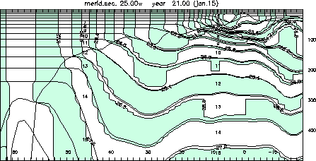
Fig. 1. HYCOM vertical section at 25°W in January of year 21. Shaded field: density. Thin solid lines; layer interfaces. Thick line: mixed-layer depth. Depth range: 500 m. Numbers along bottom indicate latitude. Tick marks at the top and bottom indicate horizontal mesh size.
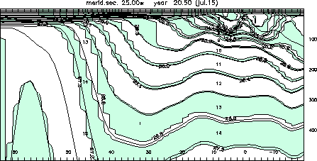
Fig. 2. As in Fig. 1, but for July of year 21.
The capability of assigning additional coordinate surfaces to the oceanic mixed layer gives us the option of replacing the present slab-type Kraus-Turner mixed layer by a more sophisticated closure scheme, such as K-Profile Parameterization (KPP) (Large et al., 1994, 1997). Development of such a new surface boundary scheme is presently underway. The KPP model is particularly attractive for several reasons. It contains improved parameterizations of physical processes in the mixed layer, including non-local effects. It actually calculates the mixing profile from the surface to the bottom of the water column, and thus provides an estimate of diapycnal mixing beneath the mixed layer. It has also been designed to run with relatively low vertical resolution, and is thus substantially more efficient than turbulent closure models. Finally, such a model can simulate the vertical structure of dynamical and thermodynamical variables along with biochemical constituents.
The hybridization work is firmly embedded in MICOM's development effort carried out at the University of Miami and now also at the Los Alamos National Laboratory. The freedom to adjust the vertical spacing of coordinate surfaces in HYCOM will simplify the numerical implementation of some physical processes (mixed layer detrainment, convective adjustment, sea ice modeling, ...) without robbing the model of the basic and numerically efficient layer architecture that is characteristic of layered models throughout most of the ocean's volume.
References:
Bleck, R., and D. Boudra, 1981: Initial testing of a numerical ncean circulation model using a hybrid (quasi-isopycnic) vertical coordinate. J. Phys. Oceanogr., 11, 755-770.
Bleck, R., and S. Benjamin, 1993: Regional weather prediction with a model combining terrain-following and isentropic coordinates. Part I: Model description. Mon. Wea. Rev., 121, 1770-1785.
Halliwell, G., R. Bleck, and E. Chassignet, 1998: Atlantic Ocean simulations performed using a new hybrid-coordinate ccean model. EOS, Trans. AGU, Fall 1998 AGU meeting.
Large, W. G., J. C. Mc Williams, and S. C. Doney, 1994: Oceanic vertical mixing: A review and a model with a nonlocal boundary layer parameterization. Rev. Geophys., 32, 363-403.
Large, W.G., G. Danabasoglu, S.C. Doney, and J.C. McWilliams, 1997: Sensitivity to surface forcing and boundary layer mixing in a global ocean model: Annual-mean climatology. J. Phys. Oceanogr., 27, 2418-2447.