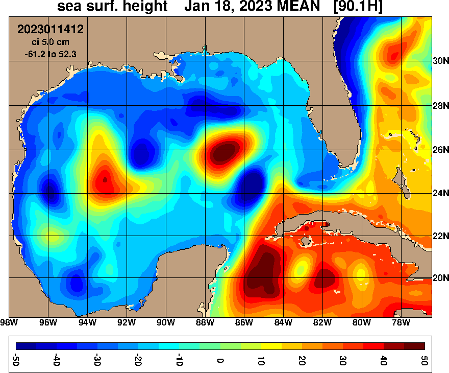
| Title: | HYCOM GOMu0.04 Analysis |
| Resolution: | 1/25° (0.04) |
| Institution: | Naval Research Laboratory |
| Date/Data Range: | 2019-01-01 to 2023-01-15 [missing data] |
| Experiment: | 90.1m000 |
| Temporal Frequency: | 1 hourly |
| Configuration: | blkdat.input |
| Topography: | depth_GOMu0.04_03i.nc |
| NetCDF Format: | Click here for unaggregated NetCDF data access (HTTP/HTTPS) |
System Description
HYCOM is designed as a generalized (hybrid isopycnal/σ/z) coordinate ocean model. It is isopycnal in the open stratified ocean, but reverts to a terrain-following coordinate in shallow coastal regions, and to z-level coordinates near the surface in the mixed layer. This generalized vertical coordinate approach is dynamic in space and time via the layered continuity equation, which allows a dynamical transition between the coordinate types. Like MICOM, HYCOM allows isopycnals intersecting sloping topography by allowing zero thickness layers. HYCOM was developed from MICOM using the theoretical foundation for implementing a hybrid coordinate system set forth in Bleck and Boudra (1981; J. Phys. Oceanogr.), Bleck and Benjamin (1993; Mon. Wea. Rev.), Bleck (2002; Ocean Modelling), Chassignet et al. (2003, J. Phys. Oceanogr.) and Halliwell (2003; Ocean Modelling).
HYCOM is maintained as a single scalable/portable source code. The Gulf of Mexico model has 1/25° equatorial resolution and latitudinal resolution of 1/25° cos(lat) or ~3.5 km for each variable at mid-latitudes. This version has 36 coordinate surfaces in the vertical. The version of the HYCOM used is 2.2.99G-i. The experiment includes tidal forcing.
Data Assimilation
The system uses the Navy Coupled Ocean Data Assimilation (NCODA) system (Cummings, 2005, Cummings and Smedstad, 2013) for data assimilation. NCODA uses the model forecast as a first guess in a 3D variational scheme and assimilates available satellite altimeter observations (along track obtained via the Naval Oceanographic Office (NAVOCEANO) Altimeter Data Fusion Center) satellite and in-situ Sea Surface Temperature (SST) as well as available in-situ vertical temperature and salinity profiles from XBTs, Argo floats and moored buoys. Improved Synthetic Ocean Profiles (ISOP) are used for downward projection of surface information (Helber et al., 2013).
-
Incremental updating over 3 hours prior to the NCODA analysis at 12Z
ISOP is a U.S. Navy product and is not available for public distribution
Experiment Details
The experiment is running at the Naval Oceanographic Office (NAVOCEANO) Major Shared Resource Center. Forcing for the ocean model come from the NAVy Global Environmental Model (NAVGEM) (Hogan et al., 2014). The open boundary conditions are provided by the operational version of the global HYCOM system, GOFS 3.1. The native HYCOM .[ab] data are interpolated to a uniform 1/25° grid (GOMu0.04), converted to NetCDF and interpolated to 40 standard z-levels. The following (5) variables/fields (CF Standard Names) are provided:
-
sea_surface_elevation (aka: surf_el, SSH, sea surface height)
water_temp (aka: in-situ temperature, Water Temperature)
sea_water_salinity (aka: salinity)
eastward_sea_water_velocity (aka: water_u)
northward_sea_water_velocity (aka: water_v)
References
- (Hogan et al., 2014)
- Hogan, T.F., M. Liu, J.A. Ridout, M.S. Peng, T.R. Whitcomb, B.C. Ruston, C.A. Reynolds, S.D. Eckermann, J.R. Moskaitis, N.L. B aker, J.P McCormack, K.C. Viner, J.G. McLay, M.K. Flatau, L. Xu, C. Chen, and S.W. Chang, 2014: The Navy Global Environmental Model. Oceanography, Vol. 27, No. 3, 116-125, http://dx.doi.org/10.5670/oceanog.2014.66.
- (Helber et al., 2013)
- Helber, R.W., T.L. Townsend, C.N. Barron, J.M. Dastugue and M.R. Carnes, 2013: Validation Test Report for the Improved Synthetic Ocean Profile (ISOP) System, Part I: Synthetic Profile Methods and Algorithm. NRL Memo. Report, NRL/MR/7320—13-9364.
- (Cummings and Smedstad, 2013)
- J. A. Cummings and O. M. Smedstad. 2013: Variational Data Assimilation for the Global Ocean. Data Assimilation for Atmospheric, Oceanic and Hydrologic Applications vol II, chapter 13, 303-343.
- (Cummings, 2005)
- Cummings, J.A., 2005: Operational multivariate ocean data assimilation. Quart. J. Royal Met. Soc., Part C, 131(613), 3583-3604.